Scan Technology
GEOSCAN
"We promote major projects for future!"
About us
SACC World GEOScan s.r.o. is holder of the principal license for advanced Scanning technology to detect any kind of Natural Resources.
They comprise the following elements:
-
Natural resources such as Water, Oil, Gas
-
Gold, Silver, Platinum, Diamands, precious stones
-
Historical findings and geochemical anomalies
-
Future expansion into different areas with the technology continually improving
GEOSCAN Technology
Introduction:
- Remote Sensing Technology (RST), developed in Germany from 2009 onwards, as a revolutionary new technology for geophysical research.
- Geophysical Spectral Analysis, based on a proprietary, complex mathematical filtering technology and analysis of resonance frequencies of atoms/molecules and their longitudinal interaction with imaginative spectrum frequence of natural sun light.
- The technology is an analogy to the MRT technology in medicine (magnet resonance tomography).
- The technology enables us to investigate the existence of natural resources with precision and to measure into much deeper surface layers than any other known process, up to 6 km underground.
- The resulting data allow for a geophysical interpretation of natural resources in the ground, including oil, gas, water, salt water, but also to scan for hollow spaces, cavities and tunnels, and even organic material
Commercial Application:
- GEOScan Technology has been commercially applied since 2015 by clients in Europe, Asia and Africa for detection and verification purposes of various raw materials.
- Typical projects include:
→ search for water to build irrigation systems in agriculture
→ verification of oil and gas fields and determination of ideal drilling spots
→ search and identification of attractive mining/extraction zones
→ analysis of underground structures in archaeological sites
→ feasibility studies of big infrastructure projects
- Due to the non-intrusive approach, the application of GEOScan Technology saves clients significant research and drilling resources, cuts time needed to determine effective and efficient drilling spots to a minimum and is environmentally friendly.
Water Survey Results GreeceA survey done for Mr. Kaltsas, a local farmer from Chrysopouli, region of Thrace, Greece.
The farmer´s first drilling in 16-20 m depth was immediately successful.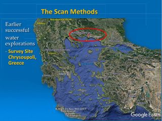
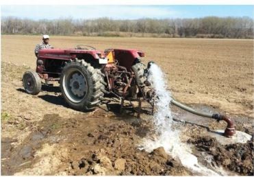
The farmer Mr. Kaltsas sent a phograph to demonstrate his success:
,, I am very grateful for that and thank the whole Team very sincerely for their work. They have saved me a lot of money. " (Mr. Kaltsas)
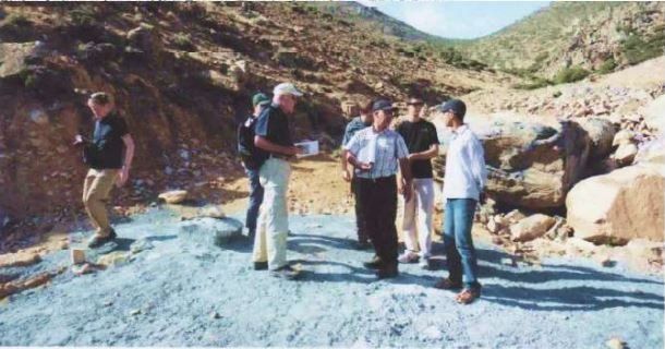
Water Survey Results MaroccoThe Technology explored five survey sights for Mr. Frost, former representative of the German Water Foundation for some of his clients in Sidi Ifni as a test project.5 locations were provided by our system to explore the information value of the technology, comparing the local knowledge about water bearings to the test results.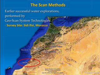
 Water Survey Results Pakistan
Earlier successful water explorations Islamakot, Pakistan.
Water was located in 160 - 180 m depth, while the drilling hit the water vein at 170m. Many companies had tried to find water by an unknown number of drilling attempts in this desert region, without success. We met the water with the first borehole.We worked for Houbara Foundation International, Pakistan in the Village of Kharo Jani, 20km north of Islamkot.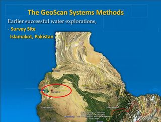 Typical Project
- Client specifies area to be scanned based on GPS data and names target material/structure of scan (note: target has to be specified, GEOScan cannot run multiple target substances simultaneously).
- GEOScan performs first level coarse-scan and delivers scans to client (duration ca. 1-2 weeks), indicating presence and approximate location of targeted substance in search area.
- Client narrows done targeted area and further objectives of search.
- GEOScan performs second level fine-scans and delivers scans to client (duration ca. 2-4 weeks depending on size and search parameters), including exact location of targeted substance and underground depth, identification of ideal drilling point(s).
- Followed, if necessary, by fine-tuning of drilling locations together with client on-site.
Cost and Timing
First Level Scan
- Indication of presence of the targeted resource
- 1-2 weeks duration after signing of assignment and payment
- EUR 30,000 per square kilometre of search area
- Will be done completely on-desk in scanning lab in Germany
Second Level Scan
- Exact location and depth of the targeted resource
- 2-4 weeks duration after signing of assignment and payment
- EUR 100,000 per square kilometre of search area
- Interaction and Refinement/ Interpretation with client
On-Site Visit
- Determination of ideal drilling spot
- Individual offer based on location and estimated time requirement
Our current projects
- Kuwait
- Saudi Arabia
- Marocco
- Canada
- Mongolia
- Oman
- Ukraine
- UAE
- Slovakia
- Poland
- Sierra Leone
- Czechia